A trip to Inis Bo Finne,
the island of The White Cow
This was my second visit to this wonderful island, seven years ago being my first, it was sunny and glorious then, I recall, this weekend was more a typical Irish summer, rain was forecasted, but I didn’t mind, I was just glad to be there.
I had very fond memories of the Inis Bo Finne (Island of the White Cow), and was thrilled with the expectation of a long overdue second visit. It’s a 50min-plus boat journey from the fishing village of Cleggan in North Connemara (See: inishbofinislanddiscovery.com for details).
I love being on the sea so any boat ride is always a thrill, no matter what the weather. I like to stand outside and take it all in. There is nothing like the slap of cold, salt-tingling sea water into the face to remind you of where you are, and the majesty of the sea.
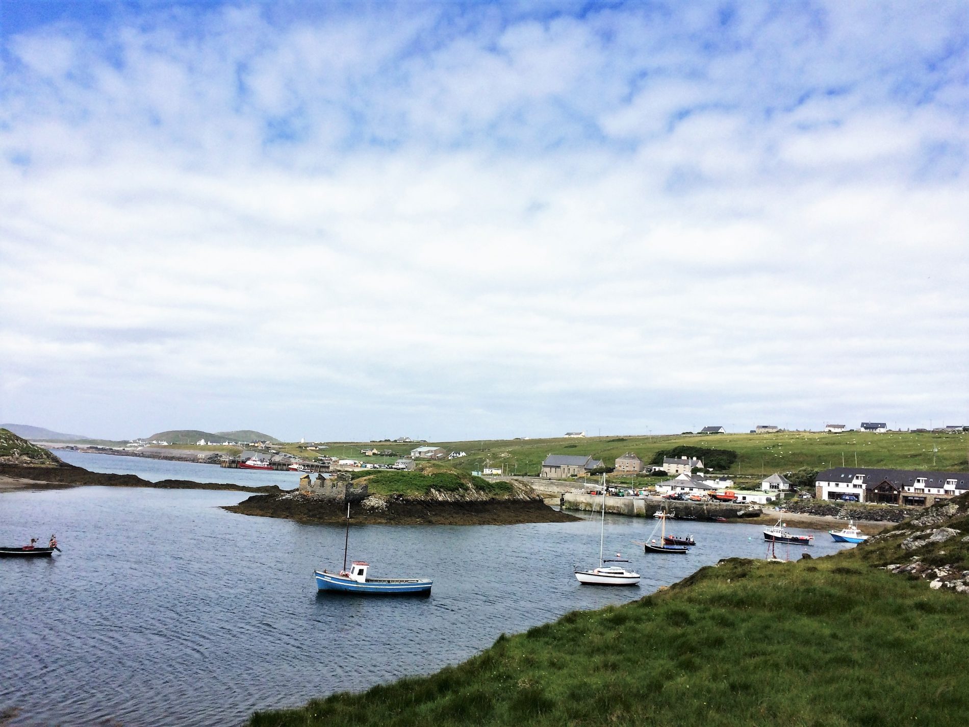
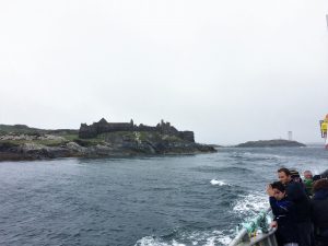
As the ferry approaches the island’s new pier, nestled in its protected natural mile-long harbour, one of the larger old signal towers comes into view, past that, the remains of an imposing Cromwellian star-shaped fort stands guard on the mouth of the harbour. It’s an impressive arrival scene for a small island off the Galway coast, an strong indication, if one were needed, that this is no ordinary island.
Some legend…
Legend has it that two fishermen lost in fog, landed on an enchanted island and lit a fire. The flames broke some spell or other and the mist lifted to reveal an old woman driving a white cow along a shingle beach, which ran between a lake and the sea. She was seen striking the cow, whereupon it turned to stone. Tradition has it that the old women and her cow emerge from the lake every seven years or to forewarn of some impending disaster. The lake in the legend here is Loch Bo Finne (Lake of the White Cow) in West Quarter village.
A brief history…
Mmm… there seems to me some vagueness and speculation around the island’s very early history.
Estimates of Bofin’s colonisation by humans vary from 8,000 to 4,000 B.C. What is odd is that there is a marked absence of typical Neolithic and Bronze Age ritual and burial monuments, like megalithic tombs, stone alignments or standing stones on the island. Now, this may indicate the possibility that the social, economic and religious conditions may have been different on the island to those on the nearby mainland, where these monuments were abundant.
While have been no Mesolithic and Neolithic sites found on the island to date, other archaeological evidence points to peoples of this era having impacted the landscape here.
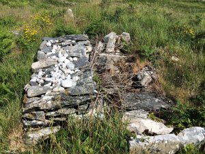
There is, however, clear evidence of substantial Bronze Age settlements, the widespread distribution of ancient stone terraces, house sites and fulachta fiadha (burnt mounds, used for cooking) point to a huge expansion of population during the late Bronze Age.
The presence of Coastal Promontory Forts, presumed to be from the Iron Age, are dotted around the island, the most dramatic been Dun Mór in West Quarter. Another Dun Grainne, is said to have been occupied by Gráinne Uaile (Ireland notorious Pirate Queen) defended the entrance of the harbour against intruders in the 16th Century.
During Cromwell’s reign (of terror, many would agree) in Ireland the regime built the imposing and well preserved star shaped fort around 1656. In later years the barracks was used to house captured Catholic clergy from all over Ireland after the English Statute of 1655 declared them guilty of high treason. Here they awaited transportation to the West Indies and other remote territories.
Strangely, Inishbofin is not part of the Gaeltacht (Irish speaking area) despite being an island off Connemara. Indeed, the island hasn’t been Gaelic-speaking for over 100 years – presumably due to the English presence there from as far back as the 1600’s.
The island had a population of 1,600 people prior to the Great Famine and it has fallen steadily since. There are currently approximately 170 people living on the Inishbofin, this number temporarily swells during the summer months, thanks to visitors.
Where to stay…
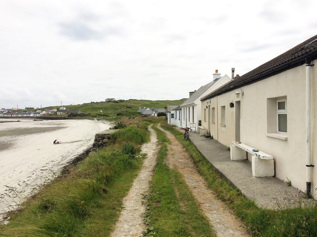
Inishbofin is unusual among Ireland’s islands in that it has three hotels, the largest, Inishbofin House Hotel and Marine is where I stayed on this trip, more on that later. The island also has three B&BS and 37-odd summer houses, of varying sizes, types (from old cottages to beautifully ones restored and newer houses) and locations, to rent. There is also a decent hostel and campsite (www.inish-boffinhostel.ie).
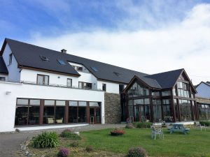
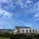
Inishbofin House Hotel and Marine Spa
If you are not on a budget and looking for close proximity to the ferry and stunning views over the harbour (ask for a sea-view if possible) then this is the spot for you. It is a modern hotel with spacious rooms, large comfortable beds (fab showers!). It has a well laid-out bar area that takes full advantage of the light and views. There is also a quieter relaxation lounge on the first floor which offers wonderful views of the sea and harbour, and is a nice space to ‘chillax’ with book, or your ‘off-the-mainland’ thoughts.
Breakfast is served in the spacious main dining room, again with views. I hadn’t had a ‘full-Irish’ breakfast for a while so I opted for that to sustain me on my first day of island-walking. While it was ok it wasn’t the highlight (I didn’t like the sausages, a common theme with me in many Irish hotels these days), the great fruit salad and wonderful yogurt from Killowen Farm of Wexford were (www.killowen.ie) though.
The following morning I opted for a poached egg and smoked salmon, sometime later, two bullets arrived with smoke salmon. I did stress ‘soft’ poached but… a small thing really.
I also had dinner in the restaurant one evening which was a very pleasant experience thanks in no small part to Anne the restaurant manager who was so friendly and a good laugh too, but don’t be in a hurry, it is island-time. The food was good, with big-portioned starters. I had a main course of Hake, which was cooked properly and really good.
The young staff in the hotel were all very courteous and helpful. When you arrive off the boat a people carrier awaits you on the pier to pick up your bags, or you, if you don’t fancy the five minute walk to the hotel. The other hotels also provide this service.
Dolphin Hotel
The last time that I was here I stayed at the Dolphin. It is a 10/15 minute walk up the hill behind the Inishbofin House. It is very nice family-run hotel on a hill over-looking the island’s south coast. The hotel also has a restaurant which was selected as part of BIM (Ireland’s Sea Fisheries Board) Fish Circle.
The Dolphin is well known on the island for its music and dancing sessions. Traditional Irish music is common place there during the summer months. Many Irish singers and songwriters of note, like Duke Special, have played here – see their website for concert dates.
The hotel also offers Eco Tours of the island, like bird watching and nature photography. They were awarded an Eco Tourism Ireland Silver award this year too. See www.dolphinhotel.ie
Doonmore Hotel
Situated West along the southern coast of the island, the Doonmore has been owned and run by three generations of the Murray family. The place has an older fashioned feel to it than the other hotels but that is part of its charm. The hotel has a homely atmosphere and a nice cosy bar, as well as a restaurant. It is a perfect spot to too to drop in for a drink, or a bite to eat on the last leg of West Quarter walk loop.
Food and drink…
An island it maybe but there’s no scarcity of places to eat, like I said the three hotels all offer bar food and full restaurant dining. There are also two other places to eat. I had an early evening meal of Pollack and chips at the Beach Day’s Bar and B&B, nothing too fancy but it really hit the spot, after a day of coastal walking. It is near the old pier directly across from Inishbofin House Hotel.
See: www.thebeach.ie
There is also the Galley restaurant (and B&B) which is situated on East side of the island. I did not eat there but it looked very nice and it also nears the lovely East End Bay too.
Where to go for a drink and a bit of craic…
The three hotels have own their bars. The Dolphin is likely to have music on so can be lively, the Inishbofin House Hotel Bar mainly caters for those staying at the hotel and I found it to have a quieter more chill-out vibe. Murray’s at Doonmore is a mix of tourists, locals and hotel guests in a more rustic setting.
My favourite was the slightly more rouged Daly’s Beach Bar. Great atmosphere, it has more of bar vibe as opposed to a traditional Irish pub one. The kicker for me was their great selection of craft beers and ciders. Many mainland bars should hang their heads in shame!
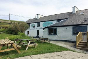
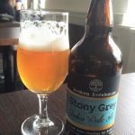
The staff too, were very knowledgeable, especially the bubbly Aisling Rooney, who recommended a wonderful IPA (Indian Pale Ale) from Brehon Brewhouse called Stony Grey (yes, a nod to their famous poet son, Patrick Kavanagh) from near where she is from in Monaghan (www.brehonbrewhouse.ie). I also had a pint a pint of the island’s only native brew a Wheat Beer called Bofin, I think… It was flavoursome, but with a kick.
Things to see and do…
It is an island in the wild Atlantic so there it is 360 degrees of beauty and wonderment, just getting out and walking all of it is the best part really.
Walking and hiking…
The best thing to do is to walk the island and there are three clearly defined walking/hiking loops on the island. I did the two main ones, the coastal ones, on the East and West side. The other, the Middle Quarter is a 5km inland loop walk to the island’s second highest point. This walk takes you through the island’s historic Iron and Bronze-age landscapes circling Loch Tána as it loops back to the harbour. It sounds interesting too.
West Quarter Loop Walk
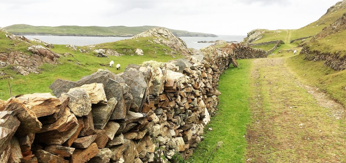
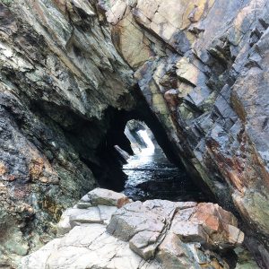
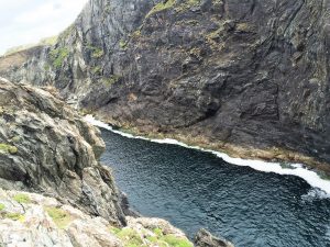
Day one, with the possibility a showers or two, I set off on the 8km West Quarter Loop. This is by far the wildest and more rugged of the walks and takes in some fabulous Atlantic coastal scenery. A highlight for me was the two blow holes and sea arches past North Beach Bay. These coastal formations are amazing with dizzyingly steep inclines. They have a menacing beauty and allure but care is needed as they can be dangerous. The steep sides provide precarious nesting sites for Shags and other sea birds.
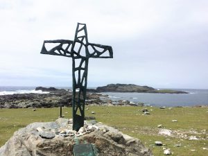
Onwards from there I went off-trail a bit, across the boggy terrain to the wonderful Stags, a series of rocky out-crops off the north western coast. A seal colony is often found near this area, there was no of them today. I passed an arresting bronze cross erected on a rock looking out to the Stags in memory of two young Kansas students who tragically drowned off there in the 1970’s. A local man told me that at low tide they got out onto the Stage but panicked when the tide came in again and opted to swim the treacherous channel back. “They were from Kansas and knew nothing of the sea,” he said.
Even those who were born to the sea suffered at the hands of its mercilessness and power. Walking the island there are several memorials to various tragedies at sea down the generations mainly involving local people. The worst of these was the 1927 Cleggan Bay disaster which claimed the lives of 45 fishermen, many of them from Bofin.
Heading south to the impressive Dún Mór Cliffs and Cove, where you can also see the ruins of an Iron Age promontory fort. From there the trail takes you back along the south shore on the famine road where you can walk down the slope to the jewel that is Trá Gheal beach. Banked by a small rocky cliff, its fine sand and aqua-blue waters a sight to behold, especially when the sun shines. I just had to take of my hiking boots and wade for a bit in the ‘fresh’ Atlantic waters. I then lay on the sand for a bit just listening to the waves and the cries of sea birds… what can I say, it was very difficult to leave.
The track back to the harbour winds over grass paths, alongside turf banks, fields and pebble beaches.
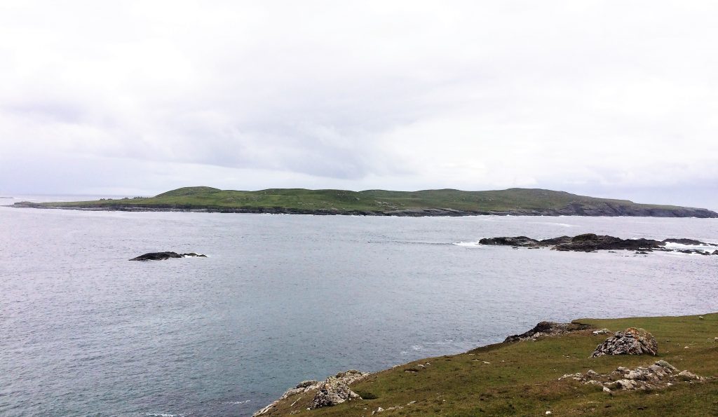
The nearby island of Inishshark can be seen clearly from here. Indeed I was told that there was a group of Notre Dame Students camping on the island on some archaeology project for some of the summer.
Inishshark was once the home to several hundred people at the peak of its population – the last 24 of its residents were evacuated in October 1960. Even then the islanders had no electricity, modern communication or running water, unlike many of the other islands. It can be completely isolated for weeks on end during bad weather. It is an interesting island in its own right and one of the most westerly outposts of Ireland (next parish Newfoundland).
You can arrange to be taken there by local fishermen, or guided trips from the Community Centre (near the harbour), you just need to inquire. The island features many echoes of its ancient past – from early Christian monastic settlement ruins, medieval pilgrimage stations to prehistoric field systems. The medieval church of St. Leo’s and some other stones houses can be seen from this track on Bofin.
Cloonamore Loop
The next day morning I set off towards the Cloonamore loop, on Bofin’s east end. This a more easy-going trail, winding down stone-walled roads, past greens fields and lovely beaches. The first main sight is the Church Loch (small lake) set in a small valley, its reed beds and surrounding land provide nesting and cover for a variety of bird life.
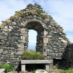
Past the lake is the 14th Century St. Coleman’s Abbey and graveyard. I can’t pass a graveyard, especially an old one. I find them fascinating places. Here new graves and ancient graves share the same ground.
Some of the very old graves are sadly being left to ruin. On my last visit there was much easier walk around the older East corner of the graveyard near the church where most of these graves are. Now, sadly it is over grown with briers and weeds.
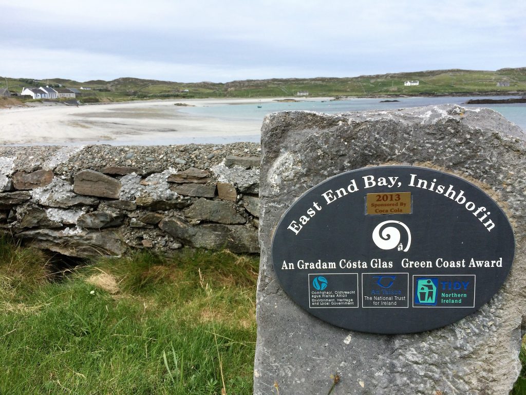
Next stop is the lovely Dumhach Beach – one of Bofin’s two Green Coast-awarded swimming beaches. This lovely beach faces towards the small Inis Laighean (island), which provides a lovely backdrop. I was tempted to go in for a dip there but decided to keep moving to the other Green Coast beach, East End Beach.
On the way to East End beach past the Galley restaurant there are some lovely restored old houses and cottages. These houses extend down to the beach and face the sea on the east side of the island along this lovely swimming beach.
The sun came out, so I had to get it for a dip. I was my third swim in the Atlantic since the end of May so I had built up some hardiness to the sea temperatures. A few minutes in, it could have been the Med, it felt almost tepid, almost… There is nothing a like a stimulating swim the North Atlantic it does something to you, it is hard to explain. I didn’t continue the rest of the loop from there up past Loch Gabhlán na nGabhair, the loop is 8km in total.
On a clear you can see Croach Patrick, Clare Island and the 12 Pins from various parts of Boffin, especially up this eastern end. I managed to see all of these and it wasn’t a totally clear day.
Cromwellian Barracks
On my final day I walked out to Cromwell’s Barracks that morning. This path is less defines, I headed out along the harbour shoreline past an old curing station across the way. I followed a vague the hilly path out to the site. The walk has great views back towards the harbour area, the main hub of the island. The fort itself is still in good enough shape and is strategically poised right at the edge of the rocks.
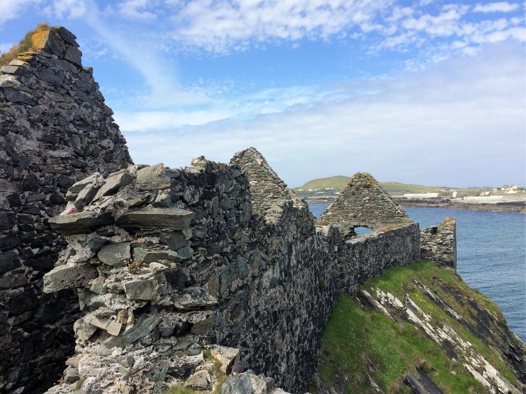
It was certainly an impressive vantage point in which to defend the all-important sheltered harbour. To the east of the barrack, at low tide, there is an interesting old crescent-shaped harbour, now mostly silted up, that played its part in allowing ships in and out of the harbour during the ensuing Cromwellian and Jacobite Wars. The Irish forces also used the barracks during the Jacobite war until their surrender in 1691 to the Williamite forces.
Other activities…
There are of course loads of other things to do on Inishbofin, bike hire is popular. There is an Equestrian Centre too. There are also several Gold Certified Eco and Historical walking tours that you can take (See Dolphin Hotel too) including one to Inishshark. Contact Inishbofin Community Centre on 095 45489 or email tommybofin@gmail.com to arrange.
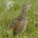
Bird watching too is very popular as Bofin is home to many species of both land and sea varirty, the rarest of which is the Corncrake, which I had the pleasure of hearing one day for the first time since I was a young lad.
Sea angling and RIB Charter too are available for private hire on the island.
Highlights for me included…
Seeing the Blow holes and Sea Arches on the Western Quarter
Paddling in the sea at the wonderful Trá Gheal Beach (Bright beach in English)
The boat journey over, especially coming into the harbour past the old barracks and signal towers
Going for a swim at East End Beach
Hearing the very rare Corncrake
The wild flowers, stone walls and smell of the sea
My nice room with sea-views at the Inishbofin House Hotel, and the place generally
An evening in Day’s Beach Bar with a few craft beers
Lowlights…
Main one for me was the amount of abandoned cars and other vehicles just left there to rust, especially on the south side of the island.
Debris, mainly plastic, strewn along North Beach on the West Quarter Loop walk.
The unfinished and abandoned landing strip in the middle of the island (locals blame the Government)
Things to be aware of…
During the Spring/Summer season there are two or three sailings a day from Cleggan (11.30am and 2pm), weather permitting, likewise departing Inishbofin.
Check www.inishbofinislandiscovery.com for the ferry schedules.
There almost no mobile phone coverage on the island (a blessing in itself). There is limited broadband even in my hotel – it was only available intermittently in one area near reception.
Pack for all weather types, it can change from sunny to wet and windy very quickly.
Only swim in designated safe areas!
Inishbofin has made great strides to become an Eco-friendly destination and has a Leave No Trace ethic – and there are codes of conduct around having minimal impact on the land and sea environment of the island. This is code adhered to by all the walking tours.
All images and text are © The Travel Czar